Mars Gravity Field: GMM-3
Antonio Genova
By tracking Mars' gravitational pull on the three NASA spacecraft Mars Global Surveyor (MGS), Mars Odyssey, and Mars Reconnaissance Orbiter (MRO) over 16 years, we created one of the most detailed gravity maps of the Red Planet. The new gravity solution includes information on the Martian tides, crustal thickness and CO2 cycle that lead to a better understanding of Mars interior and climate evolution.
The new gravity map combined with topography allowed us to derive a more accurate crustal thickness map of Mars with a resolution of ~120 km. The new gravity field also provided information on Martian tides that confirmed the presence of Mars liquid outer core of molten rock.
Changes in the Martian gravity over time have been measured to monitor the polar ice caps. For the first time, we have been able to use MRO data to continue monitoring their mass. We have measured the variation of the polar caps’ mass over an entire solar cycle (~11 years) showing consistent results with numerical predictions from the Mars Global Reference Atmospheric Model – 2010.
The improved resolution of the new gravity map enabled us to provide new explanations for how some features formed across the northern and southern hemisphere. A better understanding of Mars’ regions formation will enhance the selection of future landing sites for rovers and human missions that are both part of NASA’s journey to Mars. Furthermore, the higher definition of gravity anomalies will help mission controllers insert spacecraft more precisely into orbit.
Credits: NASA/GSFC/Scientific Visualization Studio
Mars Orbital Missions
MGS, Mars Odyssey and MRO have contributed to the NASA's Mars Exploration Program, which makes use of orbiters, landers, and rovers to investigate and monitor the planet Mars. MGS was designed to provide global mapping of the Martian atmosphere, surface and deep interior. One of the five instrument onboard was the Mars Orbiter Laser Altimeter (MOLA) that operated only until June 2001. The ranging measurements from the MGS spacecraft to the Martian surface resulted in a high-resolution topographic maps of the planet, that are still the most geodetically accurate1. The resolution of MOLA topography (Figure 1) is 1 km in latitude and 2 km in longitude at the Equator2. MGS executed its mapping mission between 1999 and 2006 in a frozen sun-synchronous, near circular, polar orbit with the periapsis at ~370 km and dayside equatorial crossing at 2 PM Local Solar Time (LST).
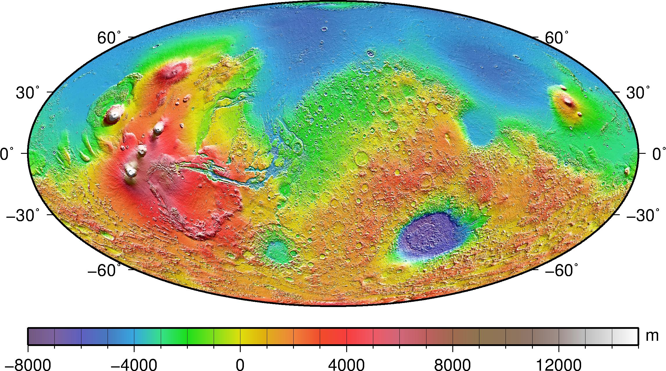
Figure 1. Map of the global topography of Mars. The projection is Mollweide centered at 0 deg longitude.
Mars Odyssey and MRO are still orbiting Mars in two different sun-synchronous, near-polar orbits with periapsis altitudes at ~390 km and ~250 km, respectively. Mars Odyssey descending node has been located at 4-5 PM LST, whereas MRO descending node is at ~3 PM LST. Both spacecraft have collected measurements at lower altitudes (~220 km) during orbit transition phases that preceded the mapping missions. Mars Odyssey started to orbit Mars in 2002 with three instruments that were focused on the study of past and/or present water and ice, geology and radiation environment. MRO was located in a low-altitude orbit around Mars in 2006. Its engineering instruments include the Gravity Field Investigation Package that has been dedicated to measure variations in the Martian gravitational field through spacecraft orbit determination.
Data
The NASA Deep Space Network (DSN) stations have acquired X-Band tracking data from these three spacecraft that provide information on the static and time-varying gravity field of Mars. The continuity of the radio tracking data, which cover more than an entire solar cycle, is a unique opportunity to also characterize the temporal variability of the gravity field, relevant to the planet's internal dynamics and the structure and dynamics of the atmosphere3.
The gravity solution depends significantly on the geodetic altitude and latitude coverage of the radio tracking data. Lower orbital altitudes provide better sensitivity to short-wavelength signals and improved gravity resolution. MRO low-altitude orbit was designed to enable the determination of highly-accurate gravity maps with a spatial resolution of ~90 km, which corresponds to degree 110 in spherical harmonic expansion.
Goddard Mars Model - 3
The analysis and processing of MGS, Mars Odyssey, and MRO data allowed us to recover the static gravity field of Mars in spherical harmonics to degree and order 120, named Goddard Mars Model-3 (GMM-3), which is available from the Geosciences Node of the Planetary Data System (PDS). Figure 2 shows the free-air gravity anomalies of GMM-3. Short-wavelength free-air gravity anomalies are driven by the widespread occurrence of isostasy from topography. Therefore, high correlations between gravity and topography harmonic expansions at higher degrees have typically been considered as indicators that the gravity solution is well determined. The new gravity solution shows higher correlations with the gravity anomaly predicted by MOLA surface topography compared to previous gravity results4.
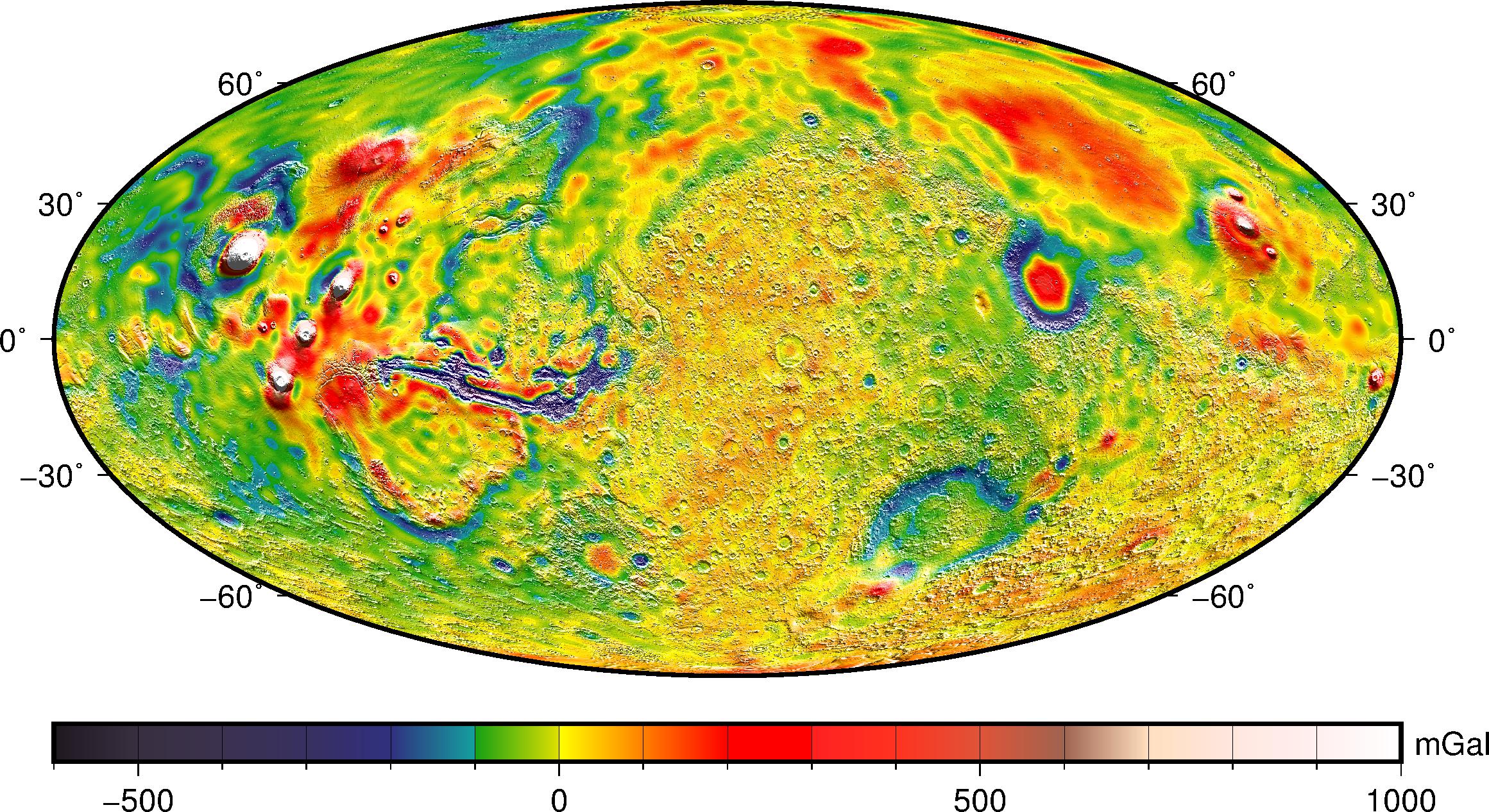
Figure 2. GMM-3 free-air gravity anomaly map.
Crustal Thickness
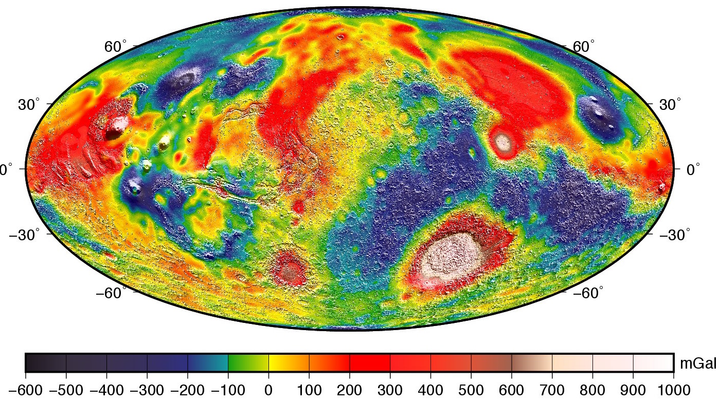
Figure 3. Global map of Bouguer anomaly over shaded relief.
